Townscapes, Buildings & Landscapes of Distinction
Remnants of underground mine workings litter the parish and have had considerable environmental and economic impact. For example huge amounts of concrete had to be sunk during the construction of Civic Square (Tindall, F. 1998 p17) and one of the parish’s most historic buildings, Elphinstone Tower, had (purportedly) to be demolished because of subsidence.
No rivers flow through the area. A small stream on the east, Seton Burn, becomes quite a flow as it enters the Firth of Forth at Seton Sands. Harry’s Burn, between Elphinstone and Fa’side, has long ago dried up, and is now just a ditch. The nature of the topography of the Heugh, a gully through the western side of Tranent, indicates it used to have a stream, but now it only appears after heavy rain, following the course of a tarmac-covered footpath to a soakaway pit near the kirk.
Any substantial waterways were – and still are – underground. They affected the coal pits and are visible today on the northeast side of Tranent on the site of the former Blindwells opencast coal mine. Here a pumping scheme is now in place to control the underground water levels and quality; part of the treatment consists of a one ha wetland site (www.minewater.co.uk). The area always seems to have been like this – the 1st edition OS map of the 1850s describes hereabouts as ‘formerly impassable marshy ground’, and it was through here that the Jacobite army made their advance before the Battle of Prestonpans in 1745.
From the 1970s, the main visible changes to the environment have been to the north of the town, at Meadowmill and the adjacent opencast site at Blindwells.
The main feature at Meadowmill in the 1940s was the two-horn bing left by the Edinburgh Coal Company and Bankton Colliery. Frank Tindall recalled ‘the rails and mechanism for tippling the hutches and the corrugated iron shelter for the ‘boy’ who had the miserable job of overseeing the operation…’ (Tindall, F. 1998 p209). By 2000 this whole area of industrial dereliction had been replaced with a sports centre, and the bing landscaped into a distinctive landmark called by Frank Tindall the ‘green pyramid’.
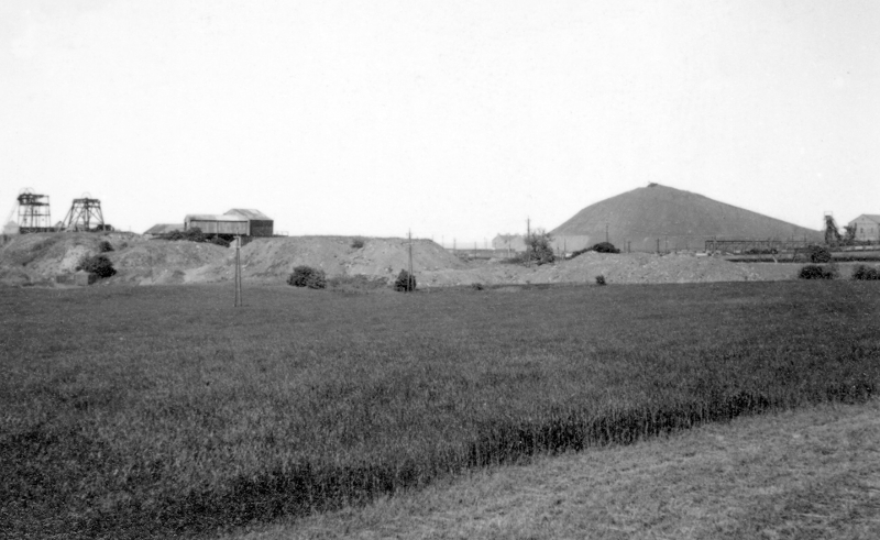
Meadowmill washer and bing, from south east corner of Bankton House garden
The layout of the Blindwells land, as reinstated both during and after the opencast operation (1976-2000) was different from before, the fields being bigger and ‘squarer’ (easier to work) – though there were a couple of big fields before. Hawthorn hedges have been planted, and copses of trees beside the bypass. The expectation that the site would be returned to prime agricultural use is now in question, for Blindwells is being mooted as a possible site for a new settlement, to accommodate some of the thousands of new houses zoned for East Lothian over the next few years. Scottish Coal is an enthusiastic proponent of the scheme (East Lothian Courier 2002 February 2).
One of the arguments in favour of opencast mining at Blindwells was that the land was pitted with old shallow coal workings which made it impossible to route the A1 bypass to the north of the town; the opencast operation would restore the land to a solid foundation (Tindall, 1998 p269). Similar advantages are not apparent for a string of new opencast mining proposals put forward in the last decade. East Lothian District Council’s West Sector Local Plan of 1978 had drawn attention to the fact that ‘the development of opencast mining techniques now allows the extraction of substantial reserves which are uneconomic to work by deep mining methods’ and suggested that a large proportion of the west of East Lothian was ‘an area of possible future interest…by the NCB’.
In the event, the pressures have come from private mining companies, which have lodged a succession of planning applications to extract the deposits. A Finalised Alteration to The Lothian Structure Plan 1994: Opencast coal and related minerals, published in 2000, sets a new framework. Walker Homes, builders of the Sanderson’s Wynd housing scheme were early applicants (East Lothian News 1991 April 26) followed by William Grant Mining Ltd, who planned a development at South Elphinstone (East Lothian News 1994 November 25). A bid from I. & H. Brown was centred on the Harry’s Burn area of Elphinstone, but the Elphinstone Environmental Campaign, supported by East Lothian Council, argued that the site was inappropriate. It has been excluded in the structure plan revision on two grounds. One is that part of the site falls within the Edinburgh Green Belt and ‘working here would be conspicuous’. On the remaining ground ‘working is also precluded within close proximity of Elphinstone and Tranent. The area to the east of Elphinstone could not be easily worked without the need for haulage of coal by road through either Elphinstone or Tranent and there is no rail alternative to this’.
All other areas in and around Tranent parish (Muirpark, Adniston in Gladsmuir parish) have also been excluded on environmental grounds, because of the high visibility of working along the Tranent ridge. In this battle between amenity and economics, first blood has gone to the environmentalists, but the war has only just begun.
Townscapes, Buildings & Landscapes of Distinction
A town’s character is strongly identified with its central retail and public space. Tranent’s High Street, though not of great significance architecturally, has a coherence based on two storey facades with slated roofs, punctuated by a few taller buildings of historic charm, particularly the former Crown Hotel (now private flats with the Belters’ Bar below) whose turret in 1972 could ‘be seen from quite a distance and may act as an identity point’ (Nisbet, 1972 p27) but has since been demolished. High Street traffic pressures have been significant during our period. The A1 trunk road to London passed along the street until the mid-1980s; and latterly there has been the need to manage the much-increased use of private cars. In the ten years between 1971 and 1981, the number of Tranent families with access to a car rose from 39.1% to 51% (West Sector Local Plan, 1987).
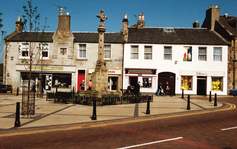
One small part of the street was designated a Comprehensive Development Area in 1953 and it was in this area that the Civic Square redevelopment took place. The initial design, completed in the early 1970s, included the post office and sorting office, government department offices, the public library, a large shop for the co-op, five smaller shops, space to be let as a café and nine flats (Nisbet, 1972 p6). A competition was held for the design of a new town clock to act as another focal point for the street. Alas, the clock was universally unadmired as well as failing to tell the time: it was replaced by another to celebrate the Millennium.
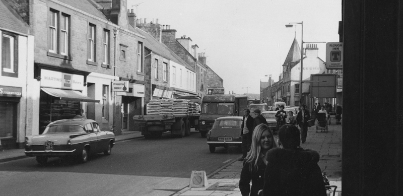
Tranent High Street, early 1970s (see turret of Crown Hotel beyond the lamp-post on the right).
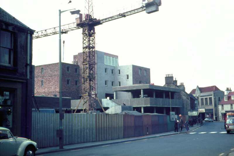
Civic Square re-development, 1970s
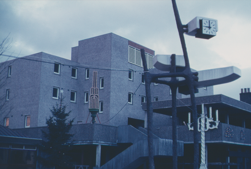
Civic Square
The narrowness of the High Street led to pedestrianisation being mooted: the idea was to take advantage of the demolition of the housing in Well Wynd and Loch Road to the south of the High Street to create a bypass road rejoining the main street at its junction with Elphinstone Road. In the event, an alternative plan was implemented, involving running a service road to the south, culminating in a cul-de-sac. This solution has produced a bare and unattractive area of parking and backlands, far removed from the vision of municipal amenity envisaged by its proponents.
Subsequently, attention has turned to the upgrading of the existing townscape. The Tranent Development Study was commissioned in 1990 by East Lothian District Council and LEEL. Resulting improvements included the widening of pavements, new crossing points added, the creation of parking and service bays and new ironwork street furniture introduced (East Lothian Council website 2002 January 8 – planning). The Civic Square itself was re-landscaped – the 1970 square never having proved attractive as a place to meet and sit – with new ironwork, a change in levels and a statue of Jackie Crookston.
One of the key changes of the last 50 years is a wider enthusiasm for local history. Tranent is one of the many towns and villages to have established a local history society (in 1988); and the new interest in the ‘people’s history’ was instrumental in the erection of the statue of Jackie Crookston in the Civic Square. The sculptor was David Annand, of Fife. The statue’s initial instability was corrected by the addition of another figure, a boy (Guardian 1987 February 7). The driving force behind the project was long-time Labour councillor Tommy Ferguson. Jackie Crookston purportedly marched at the head of the people in protest at the militia enlistment in Tranent on the fateful day in 1797 when twelve of them were killed by troops. Her name appears in the official accounts of the day as Joan Crookston but her exploits as rabble-rouser are not mentioned there – they first surface in writing in McNeill’s history nearly a century after the event.
However real she was, she exemplified for Tommy Ferguson a type of strong woman that he saw and admired among the women of the mining communities. In more modern times, Tranent has continued to produce several such women (see Local Government).
The High Street is a 19th century development. The original axis of the town was north-south along what is now Church Street, and this important area was designated a conservation area in 1969. Its historic vernacular has come to be appreciated during our period, as has the treasure of the folk art preserved on the carved gravestones in the churchyard, including the famous Margaret Johnston and her children (1662). Conservation of these soft stone monuments is an important challenge in 2000. Interestingly, Islay Donaldson who wrote the story of East Lothian Gravestones (ELDL, 1991) took the view that, like the bones underneath, the stones should be left to decay.
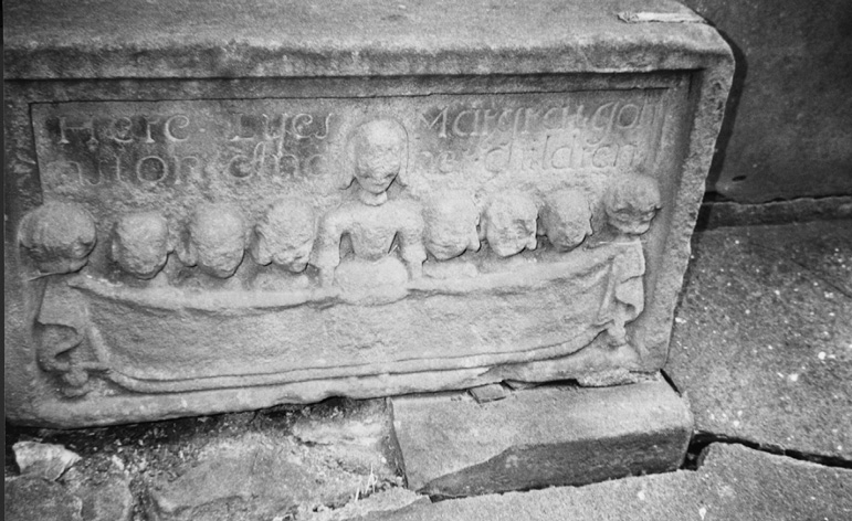
Gravestone of Margaret Johnston and her children
The rise in interest in local history from the middle part of our period is mirrored by the fate of historic buildings before and after that watershed. Stair Park (admittedly only a burned-out hull from 1914) was demolished when the site was purchased for housing in the 1950s. Elphinstone Tower – used as a Royal Observation Corps post in the war – was demolished around the same time. The Meeting House, Bridge Street, also called ‘The Bogle House’, had very small windows, and was regularly vandalised before being demolished in the mid 1960s; the launderette now stands on its site. The age of the Bogle House is not clear. There is a reference to ‘a meeting house erected in this parish’ in the parish minutes of 25 May 1701 (National Archives of Scotland, CH2/357/4) but whether it means this place is not clear.
The Church of St Andrews, built in 1843, was demolished in 1970; it never recovered from the abuse it received during the 1940s (Fasti, 1982). By the 1960s, an appreciation of the vernacular architecture of East Lothian’s magnificent farm buildings was developing, but this did not stop the demolition of East and Wester Windygoul in the 1970s and 1990s respectively.
Some buildings have had better fortune. Tranent Tower, barely recognised as an historical site until mid century, is still there, though a ruin, and East Lothian Council undertook restoration work on the walls in the 1990s. The historical novelist Nigel Tranter had been instrumental in the 1960s in drawing attention to its importance.
War Memorial, Civic Square, Tranent, 1994
Tranent Tower, 1980s
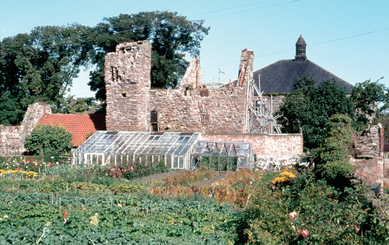
The parish boasts two great examples of restoration in Bankton House and Fa’side Castle. Bankton House, c1720, was gutted by fire in mid 1967. Under the auspices of the Lothian Building Preservation Trust, restoration and conversion into four luxury apartments was completed at the end of 1994, the work being funded by Historic Scotland, European Union and East Lothian District Council (Evening News 1995 August 22). Unfortunately the project led to the bankruptcy of the trust, and the apartments were eventually sold at reduced prices. A small visitor centre in the doocot telling the story of the Battle of Prestonpans was included as part of the project.
Fa’Side Castle, uninhabited from 1704, avoided demolition through the efforts of the Fawside Preservation Committee (set up by Nigel Tranter through the St Andrews Society of East Lothian). In the mid 1970s, restoration began under new owners Tom and Claire Craig and was completed in 1980. In 1988, the castle was purchased by James and Charmie Douglas; it was sold in 1989 to the current owner Ian Brash.
A partial good news story is that of the B listed Old Manse (1777), manse to former Wishart St Andrews Church, one of the oldest houses in Tranent but not lived in for 50 years. It was used as church storage until 1994 when sold. The new owners lodged a planning application, and restoration work began in 1996, but was not completed.