Carol Anderson & Frazer McNaughton
Introduction
The East Lothian landscape with its dune-backed sandy beaches, rich farmed coastal plain dotted with historic towns and villages and edged by the dark rim of the Lammermuir Hills, has a diverse and distinctive character much loved by those who live in and visit the area. The landscape character of the county is made up of its geology and landform, with vegetation and built elements providing the flesh on these bones. The variety and pattern of these elements combine to produce areas of distinctive ‘landscape character’. In 1998, Scottish Natural Heritage undertook a Landscape Character Assessment of the Lothians. This study considered the key features of the landscape and defined a number of ‘Character Types’ throughout East Lothian. Scottish Natural Heritage is also responsible for the National Countryside Monitoring Scheme (NCMS), which provides an objective study of changes to land cover throughout Scotland. Both the Landscape Character Assessment and the NCMS have been used in this account that considers the landscape of East Lothian and how it has changed since 1945.
The account describes the present landscape character of the county then looks back to the key factors that influenced change and their effect on the county’s character since 1945.
Visually, the landscape of East Lothian is diverse and colourful, enhanced by the light reflective qualities of the county’s coastal location. The rich pink-browns of arable fields are echoed by the common use of sandstone and red pantiles in traditional buildings. In summer, bright-yellows of gorse and oil seed rape contrast with dark greens of mixed woodlands and shelterbelts, and purple heather with pale straw-greens of rough grassland on the Lammermuirs. This colourful scene is edged by constant views of the blue of the Forth Estuary. The estate landscapes of parkland, woodlands and high stone boundary walls are important features of the East Lothian landscape and include policies associated with the ‘big houses’ such as Lennoxlove, Gosford Park, Archerfield and Tyninghame – their presence a legacy of the fertile farmland of the county.
Landscape Character
In detail, the county can be defined as having six principal landscape character types; the coastal margins; the lowland plain; lowland hills and ridges; lowland river valleys; upland fringes; and the uplands (Map 1).
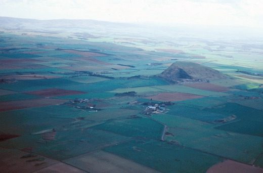
The coastal margins extend well inland due to the subtle topography of the area and strong visual association with the sea. The gently undulating to flat plain is punctuated by the igneous landmark hills of North Berwick Law and Bass Rock rising out of sea and farmland and visible from miles around. This is a diverse landscape of major policy woodlands and large fields with a strong enclosure pattern. The coast itself has subtle variations; headlands containing sandy bays to the south near Dunbar and extensive dunes and beaches backed by links landscapes to the north; and the flat open expanses at the mouth of the Tyne and Aberlady Bay, which provide a contrast along the coast with their intertidal saltmarshes and notable bird life. East Lothian is famed for its golf courses, many of these occupying the links area between sea and farmland, from Aberlady to North Berwick. The integrity of the coastal plain is lost to the west as power lines, disturbed landscapes associated with opencast coal mining and the Cockenzie power station exert a strong visual presence near Prestonpans.
The lowland plain comprises the extensive agricultural heartland of East Lothian and centres on the well-preserved county town of Haddington. This landscape comprises large scale rolling arable fields, with a strong enclosure pattern reinforced by abundant shelterbelts. The plain is interrupted by the lowland hills and ridges of the Garleton Hills and the Tranent ridge. The rugged form and gorse-covered slopes of the monument-topped Garleton Hills, are a distinctive feature to the north of Haddington while the open arable fields of the Tranent ridge offer striking views of the Forth. The lowland plain is incised by the lowland river valleys of the Gifford, Humbie and Whittinghame Waters, notable for their broadleaved woodlands, intact hedgerows and estate policies.
The upland fringes comprise a broad sweeping apron of land on the lower slopes of the Lammermuir Hills. The landscape character of the upland fringes is one of undulating mixed farmland with stone field boundaries on upper slopes; well-maintained hedgerows on lower slopes. Significant areas of ancient oak woodland remain in cleughs, which fringe and dissect the upland plateau. The high ground of the softly rolling Lammermuir Hills, which bound East Lothian to the south, offer spectacular views over the Forth from the narrow winding roads which traverse the broad plateau of the heather-clad Dunbar Common. The relative emptiness of these hills contrasts with the populated agricultural plain. Geometric and uniform coniferous plantations, power lines, and telecommunications are visually prominent man-made features within this Upland area. Just over the county border, the 26 turbines of Dun Law wind farm, constructed in the late 1990s, dominate the skyline of the Eastern Lammermuirs.
The National Countryside Monitoring Scheme (NCMS)
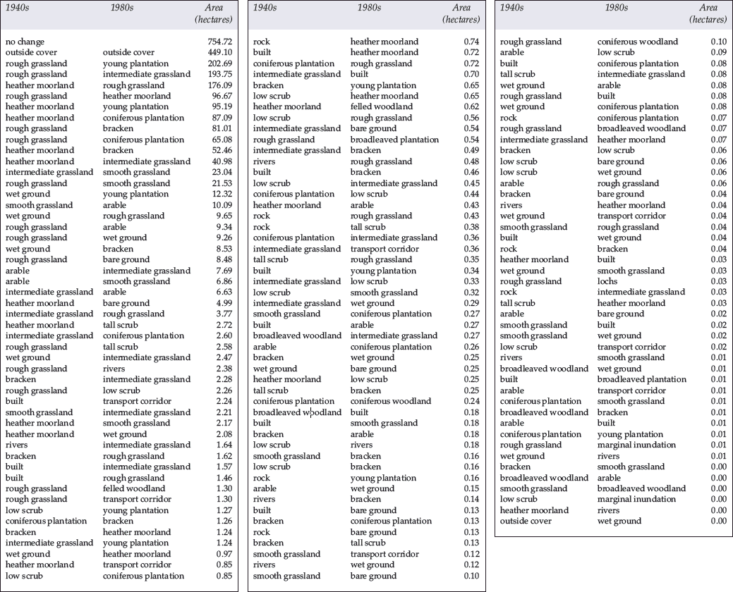
This was begun in 1986, to produce an objective account of key changes in land cover between three snapshots in time: the late 1940s, early 1970s and the late 1980s. The Scheme involved the use of aerial photographs to plot changes in features such as grassland, woodland and moorland over sample areas throughout Scotland. The Scheme has shown that in the Lothian region as a whole since the late 1940s there have been general increases in the area of coniferous plantation, built land, transport corridor, recreation and bare ground (mining/quarrying) and tracks. Rough grassland, arable, broadleaved woodland, parkland and hedgerows decreased in area.
NCMS sample squares of 1km undertaken for the Haddington area and for a plot within the Lammermuir Hills, show the particular pattern of change in land cover that is representative of East Lothian as a whole and particularly highlights general changes that have occurred in both upland and lowland landscapes.
The Haddington sample showed that recreational land increased from 4.8 to 83.6ha with a roughly corresponding decrease in parkland, due to the creation of a golf course on former estate policies between the late 1940s and 1970s. Coniferous plantation doubled in the area while broadleaved woodlands were reduced from 117 to 80ha. Grassland decreased significantly as did scrub. By the 1980s hedgerows appear fragmented and considerably decreased as fields were enlarged. The growth of Haddington is one of the most notable features however with the built area encroaching on arable land.
The Lammermuir plot strikingly displayed the significant loss of heather moorland and rough grassland, which was replaced by coniferous plantation – the area of plantation increasing by approximately a third between 1970-80s. Bracken is also shown as having considerably increased since the 1970s with an increase from 6.6 to 145ha by the late 1980s.
Overall Landscape Change Since 1945
Throughout the county agricultural changes since 1945 resulted in enlarged fields and the loss of semi-natural habitats. Lack of management also resulted in farm woodlands and particularly hedgerows becoming fragmented. Heather was commonly reclaimed and seeded to improve grazing in the upland areas and broadleaved woodlands, scrub and hedgerows were lost as productivity increased.
The type of crop grown also changed. Market gardening, which was once a feature in some areas between Musselburgh and North Berwick, diminished with only a few specialist growers remaining. In 1945 a number of productive smallholdings existed throughout the county. By the 1970s many of these were taken over by larger farms or for the grazing of horses. While the local character of intensively farmed land of these smallholdings has been largely lost, the pattern of evenly spaced houses aligned against roads and small paddocks remain a distinctive feature in areas such as Bogg’s Holdings, Pencaitland and at Letham Mains near Haddington.
Large-scale felling of broadleaved woodlands occurred in the county during the post war years with estate woodlands particularly affected. Felled areas were generally replanted with a mix of Scots pine, broadleaves and some non-native conifers. Woodland cover increased overall in East Lothian however, despite the loss of some broadleaved woodlands to agriculture. This increase resulted from the planting of coniferous plantations in the Lammermuir Hills between 1961 and 1981, and woodlands for shelter and sport on estates, using mixed species. Increased grant incentives since 1985 encouraged the planting of broadleaved planting and these new woodlands will make a more significant contribution to the landscape as they mature. The continuity of woodland management and planting offered by the estates, which are such a feature of East Lothian, secured the wooded character of the lowland landscape of the county during the period of this account, although some areas must have appeared considerably less wooded in the immediate post-war years as up to 24% of the county’s woodlands were clear-felled.
Increases in building focussed on the towns of Haddington, Musselburgh and North Berwick, which expanded to accommodate large housing estates and some limited light industry, much of which was constructed from the late 1970s. The mining-based communities of Tranent, Prestonpans and other smaller settlements also expanded to accommodate utilitarian new housing built to accommodate workers. Settlements such as Longniddry expanded significantly during the 1960s, although many of the smaller villages in the county attracted only minor new building and in 2000, still retained a strong relationship with the surrounding landscape and a distinctive architectural integrity, which is characteristically ‘East Lothian’.
Communications significantly changed within the county since the 1940s with the ‘improvements’ to the A1 being most notable. The realignment of the route brought a new perception of the East Lothian landscape for the traveller as towns and villages were bypassed; the road has a strong visual presence in the landscape. Power lines substantially increased across the county, many of these associated with Torness and Cockenzie power stations, while masts for mobile phone communications became an increasingly noticeable feature along transport corridors and on raised ground from the late 1990s onwards. The nuclear power plant at Torness, built and operational by 1985, is a major visual feature set within farmland south of Dunbar. Nearby at Oxwellmains, in 1963 Blue Circle’s cement works and an adjacent landfill site, opened in the late 1990s, together produced a locally disturbed landscape of raw disturbed ground and abandoned farms, contrasting with the rich, well-tended farmland to the north-west. In the western part of the county, the coal mining industry left areas of disturbed land and waste bings; although a few remain, many bings were cleared and landscapes restored during the 1970s. The large-scale opencast mining site at Blindwells became operational in 1977 and encroached on agricultural land, creating large-scale visual disturbance. Changes to government policy and the establishment of Torness discouraged further opencast mining proposals within the county from the late 1980s, although the 1990s saw a revival in such proposals. Many of the reservoirs in the Lammermuir Hills pre-date 1945, but the major development of the Whiteadder Reservoir was completed in 1969.
Facilities for tourists were always discreetly located on the coast and this pattern did not substantially change. A number of new caravan parks were introduced from the 1960s onwards, and the county’s only country park, named for John Muir, was established in 1976 near Dunbar. Car parks and footpaths were created to provide access to the coast. Several new golf courses and driving ranges were created, as demand for the sport increased, including one recently built on coastal farmland, near Tantallon. The special natural character of the coast has not been diminished however, as changes have been small and largely located away from rural areas.
In conclusion
Agriculture then, remained the dominant land use of the area and the proportion and overall pattern of woodland to farmland has been retained between 1945 and 2000. However, as semi-natural grassland, scrub and broadleaved woodlands have diminished, the landscape has become less visually diverse in its character since 1945. Woodland structure and composition also changed with more even-aged woodlands and a higher proportion of non-native species introduced. In the lowland areas this created a ‘new’ and distinctive character in some areas, for example Dirleton, where Scots Pine shelterbelts are a feature. In the Lammermuir Hills, the introduction of large-scale spruce plantations however, had a negative effect on the character of these once extensively-open, rounded hills.
Built development produced the most noticeable change to the landscape, mainly as it tends to occur relatively quickly and be highly visible. Most of the change since 1945 was localised and focussed around existing settlements and the visual integrity and special character of the smaller rural settlements was largely retained. There was an overall increase in lighting, communications and industrial development during the period, although again, this change has been localised rather than widespread.
Despite the changes that have occurred to the management of the landscape and the introduction of new landscape and built features between 1945 and 2000, these have not detracted from the overall visual diversity of the coastal, farmland and upland landscapes that make up the character of the county. The East Lothian landscape has therefore conserved its reputation as being one that is predominantly rural and ‘unspoilt’.