House types | Home ownership | Utilities | Shops & Services | Mobile shops
By the 1940s, the town of Prestonpans was indiscernible from Preston Village, and by 1945 had also absorbed a number of smaller settlements both east and westward. The only rural settlement within the parish is the hamlet of Dolphingstone where there has been no significant expansion in housing. Other properties isolated from the main area of housing include houses formerly attached to Prestongrange mine, which have now become private properties. However, there has been no significant building in this location.
A great deal of land has been built over since 1945: inland, most of this was either farmland or previously occupied by housing or industry. From the 1980s, the pace of change increased; the pressure on housing provision in East Lothian meant that in parishes closest to Edinburgh, resistance was futile. The types of homes built, the locations selected and the planning processes all seemed suited to people coming into the county, not to meet the needs of those already living there, and Prestonpans was no exception. Standard housing designs typical of most new private housing development throughout the UK became increasingly common. This growth has meant a change in the character of the town, from a small community where most people were known to one another, into a much larger community, housing people who work elsewhere and who do not have the same close contact with their neighbours as in the past.
As elsewhere, housing stock at the end of the war was inadequate for the needs of the population. Although a significant building programme had taken place during the 1930s, the demolition of older, more densely populated buildings meant that available accommodation had shrunk. A number of ‘pre-fabs’, (houses assembled on-site from materials prepared elsewhere) were erected at Burnside near Summerlee, but the main building programmes, which were undertaken by the council, concentrated on larger projects on ‘gap’ sites – former industrial land or land cleared of substandard housing. Most of this ‘gap site’ building took place at Ayres Wynd at the foot of West Loan which links Preston Road to the High Street – ‘Top Pans’ to ‘Bottom Pans’ – which was gradually cleared during the late 1940s and early 1950s. This included the two-storey flats of red sandstone built along the High Street, similar in design to others built before the war.
The post-war shortage of rented housing for large numbers of newly-married couples continued into the 1950s. Private housing was out of the question financially so most couples shared with parents/other families or rented spare rooms. Local (council) housing was allocated on a points system whereby numbers of children were taken into account and whether existing accommodation provided a bath or a shower.
Rebuilding at Ayres Wynd in the 1950s provided business premises, housing and a new post office, opened in 1958. Initial plans to provide premises for a new cinema were not pursued. Subsequent rebuilding created a small shopping precinct between Mill Wynd and Harlaw Hill and a number of other shops along the High Street, interspersed with two to four-storey flats. The 1950s saw the building of mainly flatted accommodation by the council, infilling old industrial sites along the shore.
Prestonpans has gone through much change since the war; it is impossible to cover everything, but Annette Gilroy’s brief descriptions below capture a little of what did change.
In the late 1940s, the south side of Rope Walk was an area of waste ground with a small coal bing and the remains of pit shafts. This was considered a great place to play by the children.
Both sides of Redburn Road and all the ground to the west and south was agricultural land, owned by Miss McNeil of Northfield House. Preston Crescent was agricultural land owned probably by Lowes.
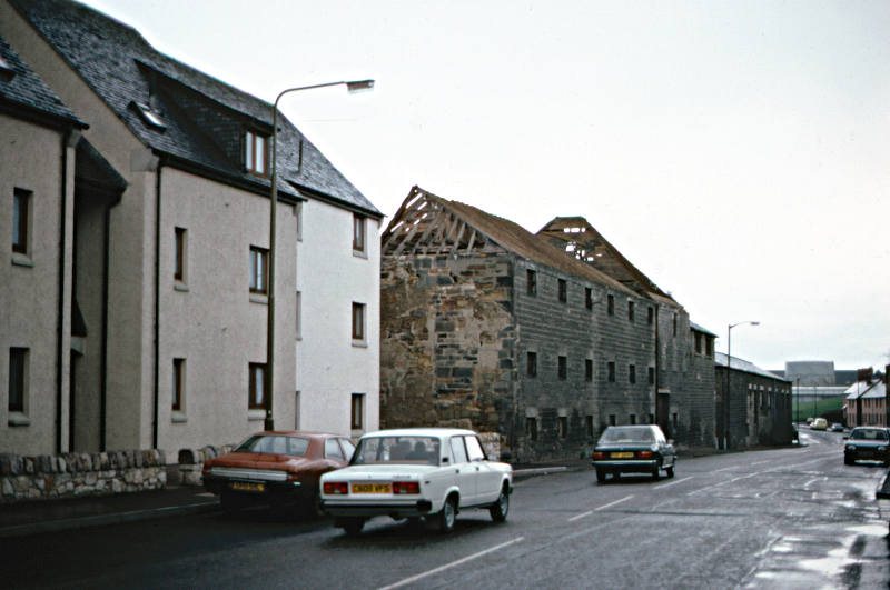
In 1957, an application for funding to widen the High Street was submitted to the Ministry of Transport. This work continued throughout the 1960s, when various buildings, mostly old industrial properties, were demolished and significant rebuilding took place, providing shops, housing and some open space. Some effort was made to preserve the frontages of these old buildings.
Unlike housing built before the war, there was a degree of concern that use of space should be maximised: the most striking example of this is the housing complex at Cuthill at the western end of the High Street. These properties, officially opened in October 1962, quickly earned the nickname ‘Ponderosa’, since its narrow walkways, low level buildings and communal garden space with wooden divisions reminded tenants of the ranch house in ‘Bonanza’, a popular TV series of the time. Their innovative design was developed by the Housing Research Unit at Edinburgh University and was intended to provide ‘community with privacy’. However, although the award winning development was the subject of national interest and was much admired, the layout did not prove popular with residents and its original layout has since been modified.
There was still some shortage of rented local authority housing but better-paid employment meant the younger generation could consider buying instead of sharing with parents. Sometimes sharing was impossible since by the 1960s the children of the ‘baby boom’ years were now teenagers and there was little spare space in most houses. From c1961-81 large-scale public housing estates were built, extending east and westward on former open land.
These were more traditional than Cuthill, and were mainly designed to provide separate houses for individual families. However, by the 1960s and 1970s, the need to maximise use of space resulted in the building of a number of flats within a courtyard setting such as those at Northfield Gardens.
In the 1960s, Prestongrange Road and Terrace, Acheson Drive, Rigley Terrace, Drummore Drive were [all built] on agricultural land. Pyper’s Wynd and Ayres Wynd were built on gap sites following the demolition of buildings and shops to accommodate the widening of the High Street. Inchview South was built after the demolition of the old Cuthill miners’ housing.
Annette Gilroy
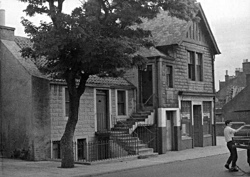
Walter Scott Pend, south side of High Street, Prestonpans, pictured 1986. As a child, Walter Scott stayed for a short time in a house on this site.
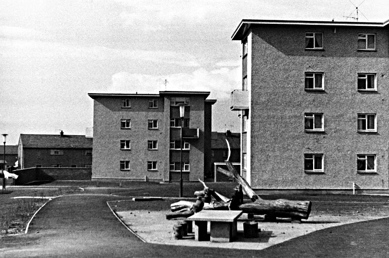
Flats and children’s playground at Middleshot Square, between Schaw Road and Preston Crescent
Open land between Schaw Road and Gardiner Road was rescheduled in the late 1960s for building purposes to accommodate the new secondary school. The site of the Pennypit, once Northfield Colliery and latterly a sports field, was opened as a major leisure facility in 1970. More modern housing was now available, but additional demand was created by single parents, divorced/separated family units and young people leaving home.
In the 1970s, Inchview North was built, again after the demolition of old miners’ housing and the re-routing of the road. Agricultural land was used for Northfield Court and Gardens. Preston Tower Gardens Sheltered Housing was built on what was previously an orchard. Burnside and Preston Crescent were built on sites formerly occupied by ‘prefabs’. Elsewhere, housing for farm workers was upgraded by a private contractor and sold.
Annette Gilroy
The 1980s saw a significant reduction in building of publicly-owned housing, and the beginning of large-scale private development, which continued to the end of the period. Although families were, on the whole, smaller, they sought more spacious accommodation; the huge increase in car ownership created parking problems especially in older, narrow streets. New-build properties offered garages, but these were frequently too restricted for any but the smallest of cars, and where the family included young adults, the numbers of cars owned were often quite high.
One large-scale building project that took about a decade to complete from 1985 was that by Wimpey Homes at Harlaw Hill Gardens off East Loan. This site was formerly the largest of the many market gardens that existed in and around Prestonpans in the 19th and the first half of the 20th centuries. This site had, in the 1940s and 1950s, been included in a council policy of preserving agricultural land.
By the 1980s, house building had stretched as far as Preston Court, Harlaw Hill Gardens, all on agricultural land. Preston Cross Cottages were built on a gap site that had lain empty since before 1940. In the 1990s, Johnny Moat House was built in what was formerly part of the school grounds. Aberlour housing appeared on the former site of the Miners’ Welfare.
Annette Gilroy
Recently, Northfield Farm on Preston Road has been demolished in preparation for housing development, although the stone facade remains. A further large-scale housing development project is currently (2000) proposed for the area on Mid Road, west of the railway station between the railway line and Mid Road, as well as housing development along the shore at Edinburgh Road.
House types
The vast majority of family housing in Prestonpans is two storey semi-detached. There are also a large number of single-storey semi-detached cottages. These types of properties usually have large gardens. There are a small number of Victorian tenement flats on New Street, some of which are entered from the High Street. A large number of mainly two-storey flats were erected along the High Street in the 1950s. The former industrial premises at Fowler’s Court comprise flats and maisonettes.
Home ownership
In the early years of the period covered by this account, the majority of homes were rented, not privately owned and the town council controlled the majority of these properties. In 1957, for example, the council managed 700 out of the 800 properties available for rent. The other major renters of property were employers such as Fowler’s Brewery and East Lothian Co-op, which housed many of their workers in ‘tied’ accommodation. Given the size of the town, it is not possible to provide a detailed description of which council properties are now privately owned, except to say that these are of significant numbers and many streets are now largely privately owned.
The shift from public to private building programmes and private ownership has affected Prestonpans: many council or Scottish Homes tenants have taken advantage of the ‘right-to-buy’ scheme. By 30 September 1980, around 37% of council properties in the town had been purchased under the scheme, with 29% resold. The newest estate in Prestonpans is the private estate built by Wimpey in the late 1980s. There are further proposals for private building both at the seaward and the upper reaches of the town.
Although the tradition still exists, few people now use the large garden area as a means of supplementing the family diet by growing vegetables (although this shows signs of changing back to an older approach), and with the need to squeeze as many houses as possible onto building land, many homes now have much smaller gardens or none at all.
Changes in care arrangements for individuals with special needs – such as elderly or disabled – have resulted in conversion or purpose-building to provide appropriate accommodation.
Whereas in the 1940s, most families included the elderly as residents in the family home, by the 1990s, a significant amount of housing for older people is available, mainly sheltered accommodation with the services of a warden.
As early as 1958-59, the trend toward separate housing for the elderly is apparent in the construction of properties specifically for this group at McLeod Crescent and at Glebe Gardens. This trend continued to 1981, with the building of sheltered accommodation by special sheltered housing agencies. From the 1990s, there was a move to joint housing projects by the council and other agencies to provide mainly sheltered accommodation.
Between 1945 and 2000, the following offered accommodation to the elderly:
Preston Lodge retirement home on Station Road: rented rooms 1940s-50s. This reverted to a family home from the 1960s to the 1980s, back to a retirement home from the 1980s-1990s, and became a family home again in 2000.
Accommodation for disabled people: due to the change from hospital- to home-based provision for disabled people, Prestonpans now has a number of either permanent or short-stay homes for such residents. Sheltered accommodation is located at Preston Tower Gardens, Blue Coat Place on West Loan and Johnnie Moat Place on East Loan (see also Healthcare).
Utilities
The condition of the outfall sewers had deteriorated during the war, and major repairs were required in 1947. In the early 1990s, the Prestonpans shoreline was part of a programme to improve sewage management, which stretched along the coastline towards Edinburgh and included the construction of additional pumping facilities within the parish.
The storage of gas for use by Prestonpans residents ceased in 1954, when the gas works near Prestongrange mine ceased production. Closure was partly due to the air pollution resulting from a deteriorating facility. By 1957, the first supplies of natural gas (mixed with coal gas supply) were made available to parish residents from a facility at Cousland.
The development of utilities within Prestonpans parish has been typical of most small towns during the second half of the 20th century, providing gas, water and electricity to all homes and rubbish now cleared from the ubiquitous ‘wheelie bin’. Additional facilities, such as cable for television, were provided in the mid 1990s.
Shops & Services
Shopping (the High Street, Hawthorn and Redburn Roads) and administration (at Aldhammer House since c1995, where the council offices are located) are centred in Prestonpans itself. In the 1950s shops were built at street-level with homes above. A new shopping centre, Preston Links, was built to the east end of the High Street, on the old brewery site, in the 1980s.
As the parish has increased in density and size, additional shopping facilities have been developed. However, this has been accompanied by an almost total eclipse of the travelling shops which provided a service up until the early 1960s. Furthermore, the arrival of the supermarket at Preston Links has meant that some local provision has been reduced (eg the Co-op at Wilson Avenue / East Loan became a day-care centre for the elderly c1980) and the development of large shopping complexes on the outskirts of Edinburgh and elsewhere had resulted in a shrinkage in the type of goods and services available in Prestonpans itself.
The range of shops on the High Street during the 1950s and 1960s included the following: electrical shop; dairy; Antonelli – fish and chips, ice cream; Jones – fish and chips; Constables – general goods; Cunninghams – grocery; West end – another grocery; drapers (two); newsagent (two); Miss Bathgate – confectionery; Mrs Donaldson – hardware; fish shop; chemist; ladies’ dress shop; Mrs Clyde – general goods; Jardine – second hand goods.
In 2000, the long-established Co-op on the High Street sold drapery, furnishings, hardware and grocery and had an in-store chemist. In 1940, Prestonpans was the only Co-op (as Musselburgh was not, at the time, part of East Lothian) not to amalgamate with the East Lothian Co-operative Society. After 1994, the Prestonpans Co-operative Society (registered 1869) was absorbed into the Scottish Midland Co-operative Society (ScotMid). At this time both the shoe shop and the butcher’s departments closed.
High Street shops included: bakeries (Fords since 1940s), Greggs (c2000); newsagent; newsagent / grocer / general shop (two); fishmonger; take-away (two Chinese, one fish & chips, and one pizza / general); cycle shop; butcher; draper / haberdashery; Safeway store; hardware store; chemist; car sales.
Ford’s bakers shop, High Street, 1960s. When this block was demolished, Ford’s re-located to a site next to the war memorial.
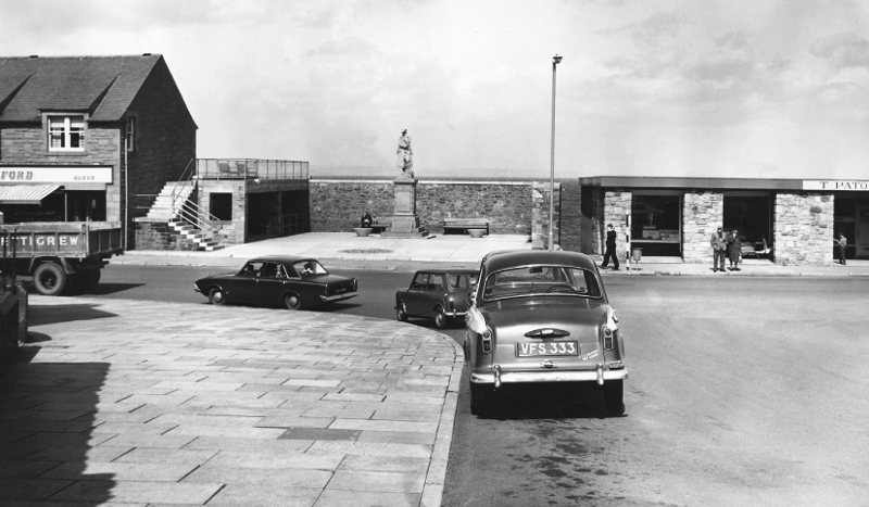
Corner of High Street and Ayres Wynd, Prestonpans, 1970s. Ford’s bakers shop is on the left and the war memorial in the middle.
On Hawthorn Road there were: from the 1970s -1980s a Co-op – with grocery, chemist / post office; the butchery section closed c1996, and the hardware section soon after; grocery / newsagent (two); public houses (two); take-away food (two, with a frequent changes of food type: pizza, kebab, Indian, Chinese etc).
On Redburn Road: from the 1970s-1980s a Co-op grocery, other grocery (one)
On Mid Road: Hastie’s general shop and garage.
Mobile shops
In the past, a wide range of mobile shops served the parish, using a variety of modes of transport. These included: Tom McKinlay’s horse and cart – vegetables; Hughie Lindsay – vegetables; Wee Bobby – firewood; Johnny Sinclair’s horse and cart (manure collected by residents) – fruit and vegetables; Anderson’s ‘bus’ type van – fruit and vegetables; Co-op bakery van – daily; Co-op butcher’s van – daily; Ramsay of Port Seton (c1950s) – butcher – daily; Banks of Tranent single decker bus (c1951-60s) – fruit and vegetables; Knight’s (c1955-60) – fruit and vegetables; Mr Cappocci (daily, 1960s) ice cream; Mr Whippy (nightly during the 1960s) ice cream (not home made); fish and chip van (from Wallyford, 1960s); Norrie Ramsay’s (1960s) ice cream; Tam Paton – potatoes (the manager of the pop group, ‘The Bay City Rollers’); Sam Wallace from Grange Road, Prestonpans – groceries; this van would supply ‘on tick’ (credit) and would collect the money at the end of the week; second-hand clothes traveller; Sam Burns – kindling, door to door.
By 2000, many only supplied advance orders. Those remaining included: fish and chip van; ice cream; organic produce; animal foodstuffs; internet orders; newspapers; coal; fresh fish.
As a commercial centre for the locality, there was always a range of services on offer, and although many of the providers of local services disappeared or changed hands over time, these services continued to be provided by others.
Post-war services provided in Prestonpans included: on the High Street, Hays – hairdresser; veterinary surgery; banks (two); and a post office. On Mid Road, Hastie’s garage (vehicle maintenance / repair) remained operational over the entire 55-year period. One ‘service’ that moved from the illegal to the legal during that time was the placing of bets via Tam Paton’s potato van; in the 1950s and 1960s, gambling was only legal at the race or dog track.
By 2000, the following services were available in Prestonpans: a main post office; the local government office for payments, the registration of births, marriages and deaths; optician; café; florist (since c1999); veterinary surgery; hairdressers (three); lawyers / estate agent (three); betting shop; cycle repair; video shop; undertaker; café / party caterers – opened c1999 (Hawthorn Road); childcare (from home); nursery; bank (one); car hire for weddings; window cleaning; plumber – working from home.
There were numerous sites for car parking; a garage / lock-up rental facility; public phones at various locations; caravan / camping at Drummohr; play parks; one public toilet; recycling services – one site taking glass, clothing etc located on the High Street, and a paper collection service.
House clearance services are offered by Sam Burns and Charles Glass. Sam Burns’ yard, tucked behind the wall along the coast road, is known far and wide for the size and extent of the goods on offer – and its layout! Besides second-hand goods, he provides a glass cutting service. For several years, a general market was held in Castlepark car park, Ayres Wynd: selling food, clothing, hardware and so on, it ceased operation c1994, shortly before the demolition of Castlepark itself.
While there were not many mobile services available in the past – the rag and bone man, and a tailor (who sold and adjusted second-hand clothes) – the only one by 2000 was a library service for the housebound.