Green Belt | Natural history | Land ownership | Townscapes, Buildings & Landscapes of Distinction
The two mines at Prestonpans – Prestongrange Colliery at the west end of the town and the Links Pit to the east, close to where Cockenzie Power Station now stands – were among the largest pits in East Lothian. An additional smaller pit existed at Bankton (although in Tranent parish), close to Preston Village. In 1945, the employees of these two large pits numbered a total of 1,488. In 1951, the male population of Prestonpans amounted to approximately 1,400, of which over 1,000 were engaged in coal mining.
Production ceased at Prestongrange in December 1962, and the pit was abandoned the following August. Prestonlinks, the last remaining underground pit in East Lothian, closed in February 1964. The remains of a disused quarry exist in the woodland between the shore road and the cultivated area of the Royal Musselburgh Golf Course. This was at one time linked to Prestongrange Colliery by a railway line. The whole area of the parish sits upon a network of man-made tunnels where coal was extracted from ancient days, probably even before the 12th century, until 1964. These tunnels, which also extend under the Firth of Forth, are so numerous and so ancient that there is no accurate record of their location and condition. Many of these tunnels have become natural drainage channels for water flowing down to sea level.
Green belt
The part of the Edinburgh green belt included in the parish of Prestonpans comprises the area now occupied by the Royal Musselburgh Golf Course, the museum, plus the former ‘farm policies’ of Prestongrange estate, the land of Dolphingstone farm and the farmland running up towards Birsley Brae, both now bisected by the A1 and its slip roads.
Although in 1955, council policy (as indicated by the Haddingtonshire Courier) was to preserve as much agricultural land as still existed within Prestonpans, the latter half of the 20th century has seen a radical erosion of this green land, until very little remains. Land has now been earmarked for a private housing development and for extension of the existing industrial site at Mid Road, between the railway line and the road which runs along the top of Prestonpans. This land lies mainly on the site of the last remaining farmland within the parish, formerly part of the old estate of Prestongrange.
Natural history
In spite of its built-up nature, Prestonpans supports a range of wildlife. The Royal Musselburgh Golf Course is home to foxes and roe deer, and hares are in evidence between Prestonpans and Levenhall, where kestrels and short-eared owls have also been seen. The old buildings and spoil heaps at the museum accommodate kestrels, swallows and, occasionally, blackbirds and robins.
A thorn tree, said to be the only growing thing left in the field after residents had cleared the crop from the fields around Nethershott, where the Battle of Prestonpans took place on 19 September 1745, survived into the 20th century as a well known landmark. By 1924, the tree was dead, although it was not uprooted until sometime during the 1960s. The Society for the Preservation of Rural Scotland erected a memorial cairn close by in 1932.
The sea and seashore forms part of the Firth of Forth Site of Special Scientific Interest (SSSI): this varied coastline is nationally important for several bird species. It is possible that sea life and feeding birds have been affected by warm water being pumped into the sea – firstly from mine workings, and secondly (from the 1960s), from the power station. Certainly the fish around here are quite big, and this area is popular with sea anglers.
Offshore and coastal birds abound – including eider duck, long-tailed duck and velvet scoter in winter. Occasionally, reed-throated divers and great crested grebes are spotted, as well as the ubiquitous oystercatcher, curlew and turnstone. The shore and offshore birds feed on small fish, crabs and shellfish, and large numbers feed on invertebrates found in beds of muddy sand uncovered at low tide.
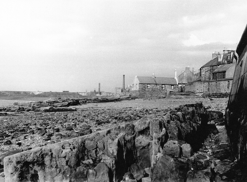
Prestonpans foreshore – the furthest chimney marks the site of Prestonlinks colliery, while the nearer one is that of Fowler’s brewery.
The shoreline has seen the most significant environmental change and has been developed as a natural resource since the building of the power station. The closure of the pits in the early 1960s has meant that the local concern evident in the 1940s and 1950s regarding the deposits of colliery refuse along the shore is no longer an environmental concern. Moreover, the grassed-over sites have, to some extent, compensated for the loss of other open land to housing development. The spoil heaps (bings) on the shore, where waste from the pits was dumped, are now overgrown and support a range of birds and animals.
The improvements to sewage disposal in the 1990s made a significant improvement in the quality of the natural environment along the shoreline. Reclaimed land forms part of the shoreline from Musselburgh towards Prestonpans and this, too, supports a varied population of animal and plant life.
In many ways, the area in and around Prestonpans is now more favourable towards the natural environment than it was in 1940s and 1950s, when the parish was an area of heavy industry and the disposal of industrial waste, pollution (and grime) from heavy industry and the building and maintenance of the sea walls to keep the industrial waste at some remove from the town were all major concerns for the parish.
There is little in the way of natural landscape elsewhere. Most urban parkland is limited to mown grass and play or sport areas. Within Prestonpans and Preston Village, the largest open areas were cultivated, mainly as market gardens. There are no longer any market gardens (see Economy – Agriculture) in Prestonpans and most of these sites are now built over (see Homes).
Land Ownership
The vast majority of land in and around Prestonpans is publicly owned. This is reflected in the large-scale housing estates which comprise the majority of housing. The housing estate on East Loan is the largest privately-owned site.
In 1945, significant private owners in Prestonpans included the Co-op and Fowler’s Brewery. The brewery closed in 1969, and some of its premises have been converted to other uses. The Co-op land and property ownership is much reduced, although there are plans for future development at the Co-op site on the High Road. Other private land is attached to private homes and therefore relatively limited in area, except for the land which is occupied by the golf course at Prestongrange and the limited amount of farmland stretching inland from Prestonpans itself, between Wallyford and Tranent.
Townscapes, Buildings & Landscapes of Distinction
Many buildings in Prestonpans are identified as of historical and architectural significance. These include the 17th century Hamilton Dower House (a National Trust for Scotland property since 1937, only open by prior agreement), Northfield House (famous for its painted walls and ceilings), Preston Tower, Boat Stone House, Prestongrange House (and its painted ceiling, dated 1581, rediscovered in 1962 and now at Napier University), the semi-derelict privately-owned Harlaw Hill House, as well as a number of public buildings including churches and several former manse houses.
Preston Cross is one of the oldest of Scotland’s mercat crosses and the oldest still in its original position. The old West Burial Ground on the High Street includes a wall set with a number of ancient gravestones. The walls surrounding the older properties are also in many cases of historical value and significance. Three doocots in the parish are listed by Historic Scotland.
The three new buildings of significance – Cuthill housing (1962), St Gabriel’s Church on West Loan (1967, by architects George Kennedy and Michael Langdon), and Cockenzie Power Station (1968, architect Chris Carter for (RMJM) Robert Matthew Johnson Marshall), reflect the changes in architectural style and materials employed in housing, churches and industry in the second half of the 20th century. The power station won a Civic Trust Award in 1972, and the Cuthill houses also won plaudits – though not from the residents!
As a long-time industrial settlement, Prestonpans has seen its land ‘recycled’ a number of times. The modern period is no exception, with the demolition of various derelict industrial buildings and houses during the 1950s-60s. On the High Street, the old saltworks, and Belfield’s pottery are no more, and at Morison’s Haven, two blocks of mine workers’ housing were demolished late in the 1950s. Castlepark (last used by the Orange Lodge) on West Loan, and Northfield Farm, Preston Road were demolished in the early and late 1990s respectively.
More positively, on Kirk Wynd, the former soapworks ‘Tower’ was used by Prestongrange Church c1970-95, and then sold.
New buildings abound; as well as those of particular note above, were Preston Lodge High School (1969, replacing the 1924 building); Prestonpans Primary School (1970) and, on the High Street, Aldhammer House (1990s).
The parish of Prestonpans is very densely populated. The area available for designed landscape is limited by pressure of house building.
Among the many historic buildings within the parish, the most significant is probably Preston Tower, built for the Hamiltons of Preston some time in the 15th century and extended upwards in the 17th century. During the early 18th century, the gardens were replanted by Lord Grange and were much visited. Restoration of some of this garden ground was undertaken in the early 1980s with a layout intended to reflect a typical Scottish garden of the 17th and 18th centuries. Features include a laburnum arch, topiary, a herb garden and a number of old-fashioned species of rose.
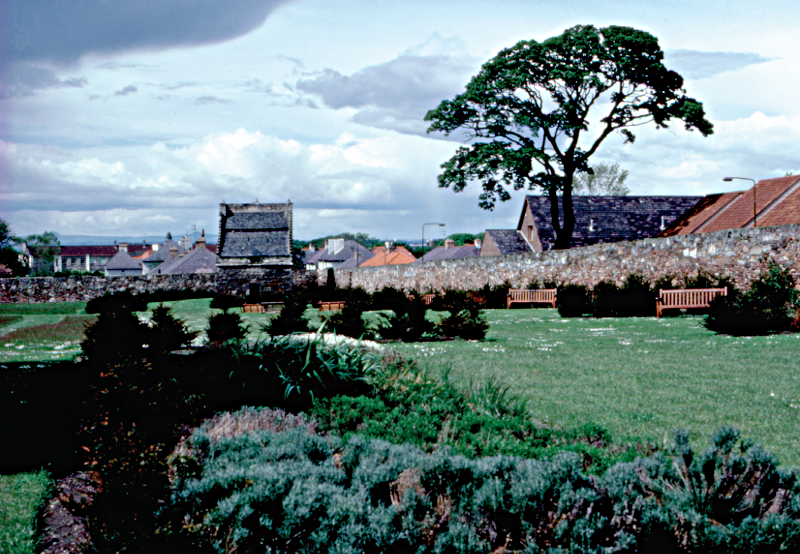
Preston Tower garden, 1986
During the rebuilding and widening of the High Street, the viewing tower above the shore and the green were refurbished to provide an area of open space amongst the shops and houses. In the Coronation Gardens, High Street a rock garden was created to commemorate the Queen’s coronation in 1953; the gardens include a statue of Thomas Alexander, former director general of the medical department of the British Army during the Crimean war. Opposite the gardens is a stone shelter built by public subscription to commemorate the centenary of Robert Burns; it was formally opened in 1959. A sculpture commemorating the town’s mining past was added in the 1970s and a stone memorial to Burns added c1997.
The former garden ground of Prestongrange House has been laid out as a golf course. Designed by James Braid, it was officially opened on 29 September 1926.