Land ownership | Townscapes, Buildings, & Landscapes of Distinction
Farmers Bill McNicol of Castleton and Andrew Miller of Bonnington comment on wildlife changes that have been noticed by both of them.
‘Hares are much less common than formerly. In the mid 1970s you could shoot 50 hares in a night at Bonnington but now they are scarce. However, rabbits have returned in numbers as they have recovered from myxomatosis and now live and breed above ground in buildings and straw bales. Up to ten roe deer frequent Castleton as well as about five herons, which feed on the shore.
Partridges have also declined greatly though they are still present in small numbers on both farms where set-aside has probably helped. House sparrows have disappeared completely from Bonnington for unknown reasons. Lapwings used to nest prior to the 1960s but have not done so since – the increased extent of winter cereals, which mean the crop is too tall in spring, and the spraying of weeds is thought to be the explanation.
On the plus side buzzards have returned to both farms – part of the recolonisation of the Lothians in the last ten years thought to result from less persecution in game rearing areas. Pink-footed geese occur in winter on both farms with increased numbers at Bonnington, perhaps because of milder winters. They are attracted to winter cereals in the autumn where they may cause some damage but are not regarded as a serious problem. At Castleton the very large flocks of wood pigeons that used to be of concern have largely gone.
Fields have got larger over the years and the few remnant hedgerows at Castleton have now gone. At Bonnington, one and half miles of new hedgerows of native species were planted in the 1970s as well as 1000 sycamores’.
While the coast boasts most of the natural interest in the parish, the lakes at Balgone support a sizeable colony of swans (SNH, 1994, p5).
There are three Sites of Special Scientific Interest (SSSI) in the parish, and one that straddles both it and Dirleton. The volcanic plug of North Berwick Law is noted for its botanical interest. Additionally there is a group of rather straggly beech trees (Fagus sylvatica) huddled together on the northeastern slope that were purportedly planted to commemorate the Act of Union in 1707.
The second SSSI is the complex dune system that extends from the west of the town, to Gullane (Dirleton parish); this area is of botanical, ornithological and geological value. The Forth Islands – Craigleith, Lamb and Fidra (in Dirleton), are an SSSI because of their seabird colonies.
And finally there is the Bass Rock; this is another former volcano, and is designated for its geological and ornithological interest. Bass Rock supports one of the largest breeding seabird colonies in the Forth.
The Bass Rock is woven into the Atlantic gannet‘s scientific name Morus bassanus. Famous for centuries, this durable plug of basalt, barely 3km from the fretted East Lothian coast, is one of Scotland’s most spectacular seabird haunts and probably the most accessible. It is, and for centuries has been, a mecca for the seabird enthusiast and the roll-call of the distinguished ornithologists who have scaled its modest height (350 feet) is long, and includes such luminaries as Ray, Willoughby, Pennant, MacGillivray, Peterson, Fisher, Tinbergen and many more.
Its most celebrated denizen, the gannet, has increased vastly in number since the last war. In 1949, the total number of nesting pairs was about 4,800 and had changed little from pre-war years. The birds were concentrated mainly on the east and west cliffs with little overspill onto the slopes above. Consequently the rock appeared mainly green, covered with fine turf, and in places with tree-mallow. Now in 2000, the rock appears white all-over right up to the summit cairn except (from the south) for a narrow strip where the path winds up. The population is now of the order of 35 to 40,000 pairs; the uncertainty is due not only to the difficulty of counting but to the presence of several thousand pre-breeding birds who have no nests and whose precise status is unclear. The increase has been at the rate of about 3% to 5% per year and could have resulted from the colony’s own output, although there have been some (probably only a few) immigrants.
The main reason for the increase is simple. Formerly, gannets were heavily persecuted and protection has allowed them to realise their natural level of productivity. If anything, their natural food supply has decreased. Herring stocks have collapsed, mackerel are fished commercially and the Danes hoover up millions of tons of sand eels from the Wee Bankie in the North Sea, one of the gannet’s fishing areas. Whether discards from trawlers have provided a significant supplementary source of food is a moot point. Nevertheless, the gannet’s productivity has remained consistently high since at least 1960 – about 80-90% of all hatchlings survive to leave the Bass.
The populations of the other nine species of seabirds have fluctuated over this period. Kittiwakes have declined from a maximum of more than 2000 pairs to around 400. As the gannets have spread onto the slopes on which many hundreds of pairs of herring gulls and some lesser black-backed gulls nested, these have decreased and now total less than 350 pairs, mainly herring gulls. A recent and unwelcome addition has been three pairs of the predatory great black-backed gull.
Guillemots have lost some breeding areas to the gannets and now number some 1,100-1,500 individuals. There are fewer than 50 pairs of razorbills. Puffins are restricted to the walls of the battlements and seem to have decreased to around 30 birds. Shags have decreased markedly from a high of more than 200 nests in the 1960s and 1970s to the current population of, in some years, fewer than ten nests. Fulmars have increased slowly but steadily to some 60-70 pairs, mainly on the sides of the gully.
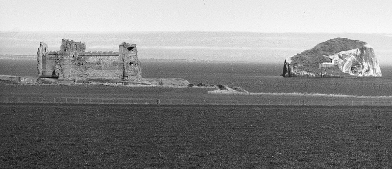
Bass Rock and Tantallon Castle, photographed from the south near Auldhame, 1989. (David Moody)
A helicopter pad, built in 1974, expedited relief for the lighthouse keepers who, previously, were taken off by boat. Although there is a brackish-water well near the garrison garden, not far below the summit of the rock, drinking water used to be piped ashore from a lighthouse vessel and stored at the base of the tower. In 1988 the light became automatic and the keepers departed. Occasional visits are made to maintain equipment but nowadays the Bass is mostly left to the seabirds.
The islands of Lamb and Craigleith lie between Fidra and the Bass and are the nearest to North Berwick but are the most difficult to land on, with calm weather and an obliging boatman essential for a visit. The Lamb is really just a large rock, home to sea birds and occasional resting seals but too small to be of much interest otherwise. The Lamb is an RSPB reserve by agreement with the owner. Craigleith (or the ‘Craig’ as it is known) is larger but again the principal interest is the nesting seabirds. The large and invasive tree mallow has colonised the Craig from the Bass since the war and now forms an impressive jungle over a significant part of the island, which is used as a roost in winter by thousands of starlings.
The breeding seabirds on both islands have been regularly counted by ornithologists since the 1960s and they have generally increased over that time as can be seen from the following table showing the numbers of breeding birds in selected years:
Land Ownership
Development in the burgh continued right through the period, eating up vacant lots and farmland closest to the town. While it is difficult to follow every transaction, some of the most important changes included the following. In the 1960s, North Berwick Town Council purchased large parts of North Berwick Mains from owner Mr Muirhead. Other parts of the Mains were sold off in the mid to late 1960s to private developers, such as the ground where Lady Jane Gardens is now. Mr Muirhead sold off the one field adjacent to the farmhouse – now Macnair Avenue. Anderson’s nursery became Abbey Court. Littledean was sold, and was developed as Marmion Crescent. In 1972 Sir Hew Dalrymple released land to the west of Glenorchy Road, and in 1985 he sold land to the west of Ware Road – the largest area ever to be developed in the town.
The North Berwick Trust was established when, prior to the North Berwick Town Council being disbanded, the councillors were concerned that the remaining North Berwick Mains land would fall, like all the other town amenities, into the ownership of the new East Lothian District Council in 1975. It was therefore decided by the town council to appoint a group named the North Berwick Trust and transfer the ownership of the remaining land on the Mains to the North Berwick Trust for the then development value of the land. The land south of Grange Road continues to be managed by the North Berwick Trust for the benefit of the community. If the ground is ever sold the original value of the land in 1975 has to be paid to the East Lothian Council and the remainder spent in the community (several millions).
In the parish (according to the 1945-46 valuation roll) post-war land ownership still rested to a degree with the historic landowners, in particular the Grant-Suttie family. In 1945, they owned Balgone, Sheriffhall (the home farm), Balgone Barns, Carperstane, Redside, and Rockville; the farms were all tenanted.
The Hamilton Dalrymple Trust Company owned Blackdykes (tenant DC Watson & Sons), and Leuchie.
With the exception of Rhodes farm (North Berwick Town Council), the remaining farms in the parish were owner-occupied: Highfield (W.D. Simpson); East Craig (Jeffrey Ritchie); Wamphray (J. & A. Fleming); North Berwick Mains (Dundas & Mary Thomson); Horse Crook & Heugh (W.J. & D.P. Wright); Bonnington (James Mitchell & Son); Castleton (J.H. McNicol) and Gleghornie (Thomson Shepherd).
The Rhodes smallholdings (nos 1-5) were owned by the Secretary of State for Scotland, and still occupied by smallholders – Thomas Somerville, James Fergusson, John Black, William Thomson and James R. Inglis.
By 2000, the Grant-Suttie family had sold Balgone House and garden (1989), and moved to Sheriffhall, retaining the estate. The Hamilton Dalrymple Trust Company still owned Leuchie and Blackdykes.
William Evans purchased the cluster of buildings on the shore at Canty Bay from Sir Hew Hamilton Dalrymple in 1923. In 1936 ownership was transferred to the Evans Trust, and remained with the trust in 2000 (see Miscellany).
Townscapes, Buildings, & Landscapes of Distinction
The burgh’s townscape is enhanced by a number of fine buildings, many of which have been listed by Historic Scotland; of particular note are Bunkerhill, Westerdunes, and Carlekemp and Carlekemp Lodge, all grade A listed buildings. The policy of the council in recent years has been to retain the character and overall attractiveness of North Berwick. This keenness to preserve the character has benefited from parts of North Berwick being designated a conservation area in 1969. The original conservation area included the original 18th and 19th century core of the town, to the south of the harbour, and this was later extended along Westgate and Beach Road. In 1981, further areas of the town were scheduled.
The architecture is mainly traditional with the use of turrets, crow stepped gables and elaborately carved bargeboards. Materials such as stone, red sandstone, natural slate, clay pantiles and harling cladding are used all of which are compatible with the locality. There has been the occasional deviation from the norm and at Fowler Court one suspects the designer has seen work by one of the more famous architects of the 20th century with a distinctive suggestion of Ronchamp in its design!
The first proposal to pedestrianise the High Street was made in 1965; in 2000, the High Street remained full of traffic, though only bearing down on unsuspecting pedestrians from one direction.
Outwith the town, almost as prominent as the Law is the curtain wall of the 14th century Tantallon Castle. Still owned by Sir Hew Hamilton Dalrymple, it was handed over ‘in care’ to the then Ancient Monuments Board by his father in the 1920s. Tantallon is now in the care of Historic Scotland, and is a major tourist attraction in the county.
Fenton Tower, on Highfield Farm near Kingston, was for most of the last century a ruin. A fortification had stood on the site since the 12th century, and the present tower was built in the 16th century, bearing the initials JC (Sir John Carmichael) and the date 1577. In 1650, it was blown up by Oliver Cromwell; from 1663 it was part of the estate of the Nisbets of Dirleton.
The Simpson family bought Highfield farm after the death of Mrs Nisbet Hamilton Ogilvy in 1920, when Lt. Col. J.P. Hamilton Grant disposed of the Archerfield Estate.
In 1998 Ian Simpson and John Macaskill decided to restore the tower and convert it into a comfortable modern residence for the 21st century. The restoration was completed in 2002.
Scattered about the parish are the old farm buildings – steadings, cart sheds and granaries – that enhance the landscape. Fortunately, while some have been superseded by the larger structures essential to modern farming, many of these rather winsome buildings have merely been abandoned, not demolished. Latterly there has been an increasing trend to convert some of them into homes, for example the steadings at Redside, at Rockville and the farm complex at Heugh Farm.
Balgone Barns, East Craig, Rhodes, Sheriffhall and Wamphray all have cart sheds and granary buildings of note. Sheriffhall also has a horse mill and a chimney; Heugh Farm also has a horse mill, as does Blackdykes.
The ‘big’ houses at Balgone and Leuchie serve to remind the parish of earlier times, when the large estates were the norm; both estates now are much reduced in scale, and their surrounding landscapes and policies add much to the general amenity of the parish.
The 17th and 18th century Balgone House is set in the remnants of an 18th century formal park, overlaid with a 19th century picturesque garden and lakes (SNH, 1994, pp22-50). The Grant-Suttie link with Balgone ended in 1989, when Balgone was bought by Alan Dean. His son Marcus Dean removed the large Victorian extension in 1992. Balgone House, the North Lodge and the Coach House are all B listed.
From 1699, Leuchie was the ancestral home of the Dalrymples (LUC, 1987, pp143-149). It is thought that, 1800-04, John Claudius Loudon worked on designs for the estate. The estate was reduced in size c1922 and, during the war years, the woodlands and parks to the north were utilised. The timber was felled and the parks used for agriculture.
Leuchie House (1779-85) is A listed. In 1960, the family moved to a house in the walled garden (designers Law and Dunbar/Naysmith). Leuchie House was then used as a convent (by two different orders of nuns, 1961-70), then a Richard Cave holiday home, and a hospice, both for the Multiple Sclerosis Society (1970-date). Leuchie remains in the ownership of Sir Hew Hamilton Dalrymple.