Townscapes, Buildings & Landscapes of Distinction
The natural history pattern in and around the town of Haddington mirrors that likely to have occurred across the county generally – one of general deterioration since the 1950s. This period of decline began during and immediately after the second world war. Farming practices have become more intensive and urban settlements have rapidly extended. Hedges have been grubbed up to allow increases in field size and more convenient use of machinery. Fields have been ploughed right up to the edges of watercourses; crops repeatedly sprayed and most weeds killed. Insect numbers and variety have declined, all affecting the food supplies of birds and other wildlife. At the outskirts of the town, housing has replaced orchards and market gardens, open fields and woodland. All these developments have, on balance, probably affected local wildlife adversely.
More happily, there are recent signs of a halt and even a partial reversal in some of these trends. There is greater awareness of the issues. For example, cessation of the use of organochlorine pesticides has coincided with a recovery in the numbers of several species of raptor in and around the town and across the county generally. As illustrations of these general trends, the fortunes of two wildlife species – one, a small mammal, the other a ‘game’ bird – are of particular relevance within the parish. These are the water vole (Arvicola amphibius, and the partridge (Perdix perdix). UK populations of both of these ‘indicator’ species have declined rapidly since the turn of the 20th century, such decline having accelerated since the second world war. It is estimated that each of these species has lost more than 90% of its respective population over the last 100 years or so.
In the case of the water vole, the causes seem to be a combination of ploughing up to watercourses, ill-advised flood prevention measures and general deterioration of the streamside and riverside vegetation. The loss of such habitats means that once a local colony is lost it becomes unlikely that other animals will move into that territory to replace it. The environs of Haddington are home to at least one of these, relatively rare, water vole colonies. Local agencies concerned with bio-diversity issues are aware of the plight of these animals and are formulating strategies to manage their conservation.
The partridge also has suffered massive decline throughout the UK. Matters are not quite so serious in the narrower context of the parish, but there has probably been a significant decline since the 1950s. The same biodiversity officers concerned with the fate of the water vole have been active also in the interests of the partridge population, and they have enlisted the help of local farmers. Hedges are being replanted. The imaginative use of ‘set-aside’ has led to the headlands of fields being left unploughed. Some have sown these headland strips with ‘game crops’ to provide seeds for the adult birds and insects for their young. The hope is that such simple measures would not only benefit the partridges and the farmer (who will profit from the income from sporting leases), but that the measures should be of general benefit to farmland birds as well as to the wild flowers and insects on which they depend. In turn this will benefit the local human population, which will enjoy a somewhat more interesting agrarian landscape than that brought about by the period of highly intensive land use we have ‘enjoyed’ over the last 50 years or so.
Backwash from Edinburgh’s housing boom continues to put the parish under severe pressure from speculative house builders, while many local people find it increasingly difficult to find affordable housing. Housing development, in turn, again puts pressure on drainage and sewage systems of the type experienced in the town’s expansion in the 1950s and 1960s. This poses possible threats of pollution of the river and, ironically, the rapid run-off from house roofs and tarmac significantly increases the chances of serious flooding.
Despite recent incentives for tree planting and appearances to the contrary, much of the parish is seriously ‘underwooded’ (East Lothian as a whole being below the national average for tree cover). The main reservoirs of deciduous woodland are on the estates to the south of the town. Too many of these trees and those within the townscape itself are of restricted and similar age classes. If the parish is not to see further decline in its woodlands and specimen tree cover a great deal more needs to be done in the way of replacement planting.
On a more positive note, there are two designated Sites of Special Scientific Interest (SSSI) within the parish, both designated for their geology. These are Bangley Quarry, with its fine sanidine feldspar crystals, and the Garleton Hills, where basaltic magmas are of particular note.
Townscapes, Buildings & Landscapes of Distinction
Haddington burgh has adapted to the changing needs of its population. It has gradually shifted from an agricultural market town to the administrative centre of East Lothian – a position that to some extent it had earlier occupied. It is home to commuters using improved road links into Edinburgh while retaining its essentially 18th century character. That the appearance of the main streets of the burgh and the area around St Mary’s Parish Church has been preserved is a credit to the work of the planners.
There has been expansion, particularly in housing and public buildings, but the rationing of land for development prevented unrestrained growth. Land was ‘recycled’ from commercial to domestic use, and vice versa – a pattern typical of a small Scottish burgh.
While some properties have been demolished, relatively little has been lost since the war; most of the important buildings have been retained in a changed format. The old auction mart, which lay between Hope Park and Fortune Avenue, has now been replaced by housing. The Nungate slaughterhouse was demolished in 1975. Binnie’s Nungate brewery became part of the tannery, which was destroyed by fire in 1969. The maltings between the Tyne and Millfield Park ceased operation in 1992. The gasworks in Rosehall went in 1963. The High Land, a four-storey tenement at the corner of Sidegate and Mill Wynd, and some adjoining buildings, were pulled down in 1965. Sandybed House (also known as Bothwell Castle) on the east side of Hardgate went in 1951. On the opposite side of Hardgate a number of houses were sacrificed in the interests of road widening in the late 1950s. The New County Cinema also stood in the Hardgate; built in 1933, it was demolished in 1990. A road-widening scheme for Newton Port also accounted for some buildings west of the Courier office. Further up Newton Port, on the east side, a house that formerly incorporated a dairy stood on what became the health centre car park.
At the western approach to the town, Gateside Farm was demolished in 1968/9 to make way for an industrial building, and the Oak Tree Services closed in 1994 after 60 years, in anticipation of the dearth of trade following the construction of the new bypass. The site remains vacant. A small estate to the north of Station Road was originally known as Hawthornbank; the mansion house, renamed Caponflat before the end of the 19th century, was demolished in the early 1950s and replaced by council housing in Beechwood Road, Hope Park Crescent and Caponflat Crescent.
A major part of the attractiveness of the town of Haddington lies in the care with which its historic buildings have been preserved and adapted to meet present-day needs. From the early 1950s to the present day, a sustained programme of renewal and restoration has protected and revived the urban landscape. Much of the town was designated as an ‘outstanding’ Conservation Area in 1969; the area was extended ten years later, incorporating other parts of Haddington.
The approach to the town from the west is dominated by the 18th century Town House and its steeple. A major project in 1953 restored the courtroom, demolished prison cells, enclosed the arcaded corn market and created a handsome vestibule. Thereafter the town bell in the steeple was again rung at 7am and 10pm, latterly mechanically. Other developments followed in Mitchell’s Close and St Anne’s Place. A ‘face-lift’ for the High Street, with improvements to shop frontages, coordinated colour schemes and ‘golden’ shop signs, was introduced – the first in Scotland – by planning officer Frank Tindall.
The Lamp of Lothian Trust, set up in 1967, restored Poldrate Mill and its complex of outbuildings at the south end of Poldrate as well as establishing the Bridge Youth Centre in an adjoining row of cottages. The 17th century Haddington House in Sidegate was restored as the Lamp’s administrative centre. The garden of Haddington House was also restored as a physic garden by Haddington Garden Trust. It is open to the public, and contains many interesting features including a laburnum walk, sunken garden, viewpoint and historic summerhouse.
The most ambitious restoration project undertaken was the reconstruction of St Mary’s Parish Church. What is apparently the oldest domestic building in the town was uncovered in the course of demolition on a site in Market Street; this has been restored, and now provides two small shops at ground level, with flats above.
The mid 18th century family home of Jane Welsh Carlyle in Lodge Street was purchased by the Orchard Trust in 1983, and let for a nominal sum to the Lamp of Lothian Trust. The Trust restored the property in 1981 (the centenary of Thomas Carlyle’s death); the Lamp of Lothian Trust took over the building in 2000. Several rooms are open to the public.
Weston, one of the Georgian houses on the south side of Court Street, became the police station in 1955, while the Bank of Scotland and the Royal Bank of Scotland occupy two handsome detached houses on the north side.
When the regional authorities were replaced, East Lothian became a unitary authority. As various functions were ‘disaggregated’, extra office accommodation had to be created (principally) in Haddington. This resulted in a major extension to the 19th century council offices in Court Street and Brewery Park, completed in 2000 and now known as John Muir House. The Co-operative Hardware Store (the tearooms closed 1960) in Lodge Street became council offices in 1984.
The present Knox Academy was built in 1938. The old Knox Institute with its dominant statue of John Knox was converted to sheltered housing in 1985. Tenterfield House, Dunbar Road ceased to be a Christie Home for orphans in 1950; from 1950-92 it was used as a children’s home by the local authority. After being on the market for two years, it was sold in 1994, and was converted to flats in 1995. The Church of Christ in Newton Port was created from a butcher’s store in 1979. The Kingdom Hall (Jehovah’s Witnesses), near the West Mill, was a camera club till 1979. John Brown’s Church, off Market Street was converted to housing in 1989. Trading as Poldrate’s in 2000, the Tyne House Hotel next to Poldrate Mill was converted to flats with a ground-floor restaurant in 1982. The Kilspindie Mill shop in Market Street closed in 1990 and the factory was demolished in 1991. Part of the building later became flats.
The West Mills site is now separate workshop/business units. Kennedy’s Garage, established 1895, and operating as a coachbuilder in the early years of the motor trade, relocated from Hardgate to Knox Place, and then ceased trading in 1995. A block of flats – Kennedy Court – was built on the site.
The former fire station in the Sands was converted to Peter Potter’s Art Gallery and Café in 1975. Maitlandfield was converted to a hotel in the mid 1960s; Brown’s Hotel conversion from a private house in the West Road was in 1973. A series of buildings on the east bank of the Tyne near Nungate Bridge was converted to a restaurant and bar known as the Waterside Bistro in the early 1980s, while cottages in Mitchell’s Court, occupied for some years as a pottery, were also converted to a bistro called Breezy’s in the 1990s.
Industrial expansion took place at Gateside and along Hospital Road (see Economy -Industry). There are farm machinery showrooms and repair workshops on Bypass Road and Mill Wynd. Other industrial developments and small business units have been created in the Peppercraig Industrial Estate north of the A1, and Station Yard (off Hospital Road) in the ground formerly surrounding the railway station.
Other new buildings include the rugby pavilion (1963) in Neilson Park, extended 1969; the new fire station in Court Street (1964); the sewage treatment plant at the eastern end of Amisfield Park; two primary schools; the golf clubhouse in Amisfield Park (1972); the swimming pool (1974), substantially extended as the Aubigny Centre in 1991; the ambulance centre in Lydgait (1974); the squash courts (1978) and Florabank Park, which became a nursing home in 1984. A new health centre, built in Newton Port in 1985, incorporating a former 18th century barracks, was further extended in 1997. A building, which serves as offices and much-needed storage space for the library and museums service, was provided in Dunbar Road in August 1996. A new Scout hall was built near St Mary’s school as their old wooden building in Brewery Park was demolished as part of the John Muir House project. A small supermarket (Laws) was built in 1982 behind existing stone shop fronts in Court Street.
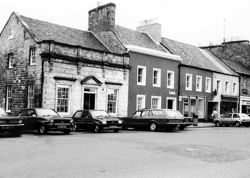
Laws supermarket, Haddington, 1980s
The wider parish is well served by an array of country houses, some of them remnants of long-dispersed estates.
Formerly a private house, at the start of the period Alderston was the Agricultural Workers’ Convalescent Home, which, with the introduction of the National Health Service, was converted to a nurses’ home. From 1975 it was occupied by the department responsible for water and drainage in Lothian region. After 1994 it was adapted to be used to train young people under the government’s Youth Training Scheme, and when that was abolished, it became part of Jewel and Esk Valley College as an adult education centre.
The Clerkington estate lies to the south of the Pencaitland Road. The main entrance lodge lies opposite Clerkington Road. Built in 1785, the house was in army use during world war two. Returned afterwards to the previous owners, a son, Ludovic Ford, occupied it; he emigrated to Jamaica in 1951. On sale later that year, it was said to have four public rooms, 18 bedrooms, six dressing rooms, six bathrooms, kitchen and servants’ quarters. A proposal to convert it into flats in 1955 came to nothing, and by 1972 the house was ruinous and was demolished.
The ancient home of the Brouns at Colstoun is a house of many periods, and is B listed. During the war period it remained a home for the Broun Lindsay family as it did thereafter. Captain C.G. Broun-Lindsay died in 1989; his widow and their daughter reside at Colstoun. Their son, Ludovic, succeeded his father as laird of Colstoun, and lives nearby. In 1990-92 the house was reduced in size. Colstoun remains a home of an original family (although the baronetcy passed to another branch of the family in the 18th century), with an estate and historic artefacts.
Lennoxlove (formerly Lethington) was owned originally by the Maitland family, and later sold to Lord Blantyre. This property, which incorporates a tower house, has been the seat of the Douglas-Hamilton family since 1946. The 14th Duke of Hamilton purchased the estate when his former home of Hamilton Palace succumbed to subsidence. Lennoxlove has a well-maintained working estate, which includes a sawmill. The house has been promoted as a visitor attraction, with guided tours in season, a restaurant and tearoom. On the night of 29 May 1997 a carelessly discarded cigar at a corporate event caused a disastrous fire in a ground floor reception room, which had been restored by Sir Robert Lorimer in 1912. Some historic paintings suffered damage, but the room was again successfully restored, with some modification of the ground floor layout, and the installation of a lift. The 15th Duke still sometimes resides at Lennoxlove.
The original house at Huntington (formerly Nunlands) was remodelled and extended in the 18th century, giving it a Georgian character. Soon after world war two it was the property of Commander Wilfred Crawford RN, who ran a national hunt yard there. His son, who inherited the property, sold the house and gardens in 1992 while retaining the hunting lodge.
Letham House dates from 1690, modified in 1810, and the estate in 1890 included seven farms, the property of the Buchan Hepburn family, of Smeaton Hepburn, Prestonkirk. No changes were made to the house during the period of this account, but in 1970 the cottages and the stables were converted, each to form two houses.
William Burn designed the present house at Monkrigg in 1832. It has not been structurally altered in the past 50 years, but the interior was remodelled in 1948. After world war two, the property became the possession of the Manclark family, a member of which still owns and occupies it. The house is B listed.
The present house at Stevenson is largely a 16th century building, replacing the original, destroyed by the English in 1544. The Sinclair family owned the small estate for generations, until Lady Sinclair, a widow without children, died. In 1931, William Brown Dunlop of Seton Castle acquired the house and policies, but he never lived there. Occupied by the army during the war, the house was in a chaotic condition when inherited by his son Dr John Dunlop in 1946. With members of his family he restored the house and garden, and on completion in 1958 handed it over to the Brown Dunlop Country Houses Trust, with an endowment to ensure its future preservation. When Mrs Dunlop, a widow, died in the late 1990s, none of the surviving members of the family was in a position to take on the responsibility of the A listed building. It was put on the market, and bought in 2000 by Mr R.A. Green, with considerable work required to bring it up to 21st century standards.